I am studying in the 10th grade of Farajova Inji Ammar gizi Khanum Gizlar Lyceum. I am one of the best students in school. At the initiative of the Chairman of the Supreme Assembly of the Nakhchivan Autonomous Republic, I decided to participate in the «Researchers of Tomorrow» project. The main reason for my participation in this project was to gather information about the most dangerous and feared earthquakes for our region among natural disasters. He was more interested in which areas of the Nakhchivan Autonomous Republic had more and stronger earthquakes, which areas were more dangerous, the seismicity of physical objects in the autonomous republic and what students did during the earthquake. Therefore, the head of the Seismological Service Department of the Institute of Natural Resources of the Nakhchivan Branch of ANAS, Ilkin Muallim, began to teach me the rules of carrying out this work. The first acquaintance was about seismic stations installed in the country and I saw how earthquakes are processed. There are 4 high-quality US-made Kinemetrics telemetry stations in the Autonomous Republic. These stations are located in Ordubad, Babek, Shahbuz and Hyderabad. The STS-2.5 seismometers installed at these stations are made in Switzerland and the signals are transmitted via satellite. Earthquakes in the region are recorded by a modern computer installed in the Seismological Service Department, and their processing has been carried out since 2016 through the Antelope program. The First Teacher introduced me to the principle of their work. In my physics textbook, I learned that mechanical waves determine the epicenter, hearth time, depth, and strength of earthquakes using p and s other waves, and that earthquakes are both transverse and longitudinal waves. As a result of the application of modern technology, I have witnessed the registration of earthquakes in the region without loss, the speed of earthquake processing has increased, tracking changes in the epicenters and determining the epicenter of the earthquake with high accuracy. The Seismological Service Department carries out the process of processing local, near and far earthquakes. My research is to study the seismicity, seismic hazard of the autonomous republic and the seismic resistance of students at my school. The teacher briefly informed about the geological and tectonic structure of the Autonomous Republic, and I came to the conclusion that the region where we live, the village where I live, the school where I study, in general, the area where we live is distinguished by its seismicity. The whole territory of the Nakhchivan Autonomous Republic is located in a 9-point seismic zone, but the duration of earthquakes of this magnitude in the area is different. At different times in history, strong earthquakes have occurred in the region where we live, and their epicenter maps have been built. Earthquakes in the Autonomous Republic began to be studied orally after 906, and we find them in manuscripts, historical books, archival materials, and excavations. Scientific research began after 1951 on the basis of data from a seismic station installed in the area. This was my first acquaintance with the first teacher and my first question. Why does an earthquake occur? How does an earthquake occur? This question intrigued me. The teacher began to explain to me simply that earthquakes happen, and I learned that this event is related to the dynamic processes going on inside the earth. He said that as soon as the earthquakes occurred, the collision of the Arabian plate with the Eurasian plate at a speed of 20 mm per year began 13–11 million years ago and has been dragged 200–600 km north since the collision. For this reason, he reminded that in different years of historical periods, earthquakes of different magnitudes occurred in the region and caused destruction. Historically, almost all of the territory of the autonomous republic, which has experienced strong earthquakes in the north-west and north-east of the Islamic Republic of Iran near the region where we are located, has been affected by these earthquakes. In the city of Tabriz and its environs alone, about 130,000 people were killed in three strong earthquakes in the 18th century. Strong earthquakes that occurred throughout the territory of the Republic of Armenia were felt at different intensities in the territory of the autonomous republic. Earthquakes in Daralayaz district in 735 and 906 were estimated at 8 in the territory of the autonomous republic.
It should be noted that on February 13, 2021, an earthquake with a magnitude of Ml = 5.2 in the Vedibasar basin was felt throughout the Nakhchivan Autonomous Republic. The 1976 Chaldiran earthquake and the 2011 Van earthquake in the southeast of the Republic of Turkey covered the entire territory of the autonomous republic. I decided to note what the teacher said about seismic danger in the autonomous republic and the seismic stability of the population, and I wanted to share with you.
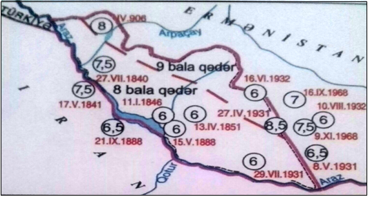
The epicenter map of strong earthquakes between 1900–2015, 2003–2016, and the regular maps compiled increased my interest in this field.
Tabriz, Marand, Tasuj, Khoy, Siyah-Cheshma, Chaldiran, Van, East Beyazit areas located on the southern and south-western border of the Nakhchivan Autonomous Republic are assessed as having a higher level of seismic hazard (a = 0.6g).The territory of Armenia is represented by three main seismic zones: Gyumri, Vedibasar (Ararat) and Zangazur. The results of microseismic zoning based on geophysical and geochemical measurements, the location of the territory of the Republic of Armenia in the maximum acceleration zone of 0.3 g — 0.5 g indicate high seismic hazard. The territory of the Nakhchivan Autonomous Republic is located mainly in the areas along the Araz, 0.2 g, and in the foothills and high mountains in the maximum acceleration zone of 0.3–0.4 g, which generally indicates the high seismic hazard of the area. Accordingly, the reconstruction and construction work carried out in all settlements of the autonomous republic is carried out on the basis of these seismic standards. The standard of construction of residential buildings and other physical facilities with a service life of not more than 50 years depends on this degree. Taking this into account, it can be said that the assessment of the Nakhchivan Autonomous Republic in terms of seismic hazard is important and relevant. In the temporary seismic zoning map of the territory of Azerbaijan compiled in 1989, the territory of the autonomous republic is divided into 9-point seismic zones. Study of seismic zones of the area, identification of potential foci, seismotectonic and other research works serve to assess seismic hazard and seismic stability, in general, seismic risk.
Seismic risk assessment is influenced by economic, social and other resilience factors. Destruction and damage of physical objects during an earthquake are due to ground vibrations. Given the fact that the maximum vibration effect (8–9 points) of strong earthquakes that occurred in different periods of history within the Autonomous Republic is observed in the foothills and mountainous areas, it is possible to say that the future event is very unfortunate. From the point of view of seismic danger, the supply of strong earthquakes from the territory of Armenia falls on the vibration zone of the autonomous republic, which increases the probability of high risk in brick and stone houses, the construction of which in the villages and settlements of border regions is not so economical.
Assessment of seismic sensitivity of objects of special and important importance in the Autonomous Republic in terms of seismic safety is reflected in the documents and is carried out taking into account the potential dangers of improper use of anti — seismic devices and rules of conduct during earthquakes, taking into account increased seismic risks in the region. The damage was caused by the low level of seismic resistance of buildings and structures and the lack of attention to special-important buildings, low public awareness, socio-economic situation, etc. A number of factors have led to serious problems. In order to prevent such cases in the future, engineering structures with high quality seismic resistance are used in the construction of physical facilities under construction in the country, and a control mechanism is implemented. During the Soviet era, the construction of most houses and buildings did not take into account the real seismic hazard of the area. The growing economic potential of the Autonomous Republic has created conditions for the rapid strengthening of all buildings and structures built during the Soviet era, the implementation of infrastructure and social facilities built during the years of independence in accordance with construction standards. Construction and installation works carried out in the territory of the Nakhchivan Autonomous Republic, complex reinforcement works in old buildings increase the seismic resistance of these residential buildings. These complex measures are implemented with high quality in every village in every district of the Nakhchivan Autonomous Republic. Seismic resistance criteria are significantly appreciated in the newly built infrastructure. This increases the resistance to future seismic vibrations.
At the insistence of the teacher, I was asked to conduct a survey of students at my school on how they behave during an earthquake. And I managed to conduct a survey in the form of a small questionnaire, and I present the questionnaire to you
Questionnaire from a number of children on «What to do during an earthquake».
Today, on November 22, 2021, I will talk about the survey conducted with my classmates at the Nakhchivan Girls' Lyceum and with my fellow students in the talent course. Our topic was «What to do during an earthquake». My goal was to find out if the children in the school and the preparatory school were safe. These were the survey questions.
- Have you ever witnessed an earthquake?
- What did you do this time?
- Do you think what you did was straight?
- What would you do if you were a witness to a powerful earthquake?
First, let's talk about the answers to the first question. Due to the similarity of the answers, I do not want to give personal answers. In general, not everyone was strong, but they said they witnessed a low-magnitude earthquake. It turned out that there was no information about the location of the epicenter in Nakhchivan or in the border areas.
In response to the second question, the following views were voiced:
- Valizadeh Sema, a student of Nakhchivan Girls' Lyceum: She said that she was asleep at the time of the earthquake, and then woke up due to the earthquake.
- Mikayilzadeh Sevinj, a student of Nakhchivan Girls' Lyceum: He said that he was sitting on the sofa when the earthquake occurred.
- Huseynli Leyla, a student of the talent course. Our student never felt the earthquake, but his parents felt it and took Leyla out.
- Let me note that the most impressive event among the students is the student I will name now. Suleymanova is a student of the Pearl Talent Course. Pearl felt that the P and S waves, known to everyone involved in seismology, passed under the house during the earthquake.
In general, everyone defended himself. However, their responses during the earthquake were not complete and correct. True, 80 % of the 17 students said they would stand in the corner of the classroom's interior walls and under the desk during the earthquake. But this does not help us at all. However, it is gratifying that some students were able to perform at least 1–2 actions correctly. However, some students still consider it appropriate to run outside during an earthquake. I undertook this work. Thus, as a citizen, I felt obliged to be a means of informing and protecting several children. With the help of the teacher, we prepared a slide and held it in the form of a discussion at our school, showing it to our classmates and other students and teachers and answering interesting questions. I tried to share with students what I learned in this project.


