


The economic development of the Arctic region is today an important task of environmental management of the Russian Federation. The development of the northern territories of our country is proceeding at a rapid pace. Meanwhile, the Arctic zone is distinguished by the extreme vulnerability of natural ecosystems, which are easily destroyed not only under conditions of climatic changes, but also under anthropogenic impact.
The development of computer technology allows to use modern research methods to reduce the negative impact on the environment, improve energy efficiency and resource conservation, reduce the hazard impact of natural and man-made origin and lessen their consequences.
GIS is an effective tool used in the management of spatially distributed risks. By using GIS technologies, it is impossible to eliminate the threat, but it is possible to indicate areas with high susceptibility where and when hazard occurrence is likely to happen, which allows researchers to focus on high-risk areas to prepare in advance.
One of the GIS methods of spatial risk assessment is a homogeneous zoning method. It is the process of multifactorial division of the territory into many non-intersecting holistic regions, aimed at identifying their differences, which determine specific ecological situation of each region [1]. This method allows to assess spatial distribution of natural and man-made hazards marking their presence or absence in a specific area. Furthermore, homogenous zoning method allows to create multiple-hazard maps which combine assessments of two or more natural hazards on a single map [2].
In this paper, the method is used for a preliminary assessment of hazard distribution in the Arctic zone of the Russian Federation. Research dataset was taken from open sources.
During the first stage of the research the factors influencing the susceptibility of the territory (increasing hazard likelihood) were singled out and united into semantic groups. To avoid the use of subjective expert evaluation, all values of the influencing factors were considered equal.
Secondly, in order to zone the research territory 11 spatial layers were created. These layers correspond to the spatial distribution of 11 risk factors including 6 natural risk factors: karst-suffosion processes, landslide processes, gully erosion processes, wetlands, seismicity, presence of permafrost. For assessment convenience of possible negative impact on settlements and communications, there were also added 5 man-made risk factors such as: settlements, roads, railways, oil pipelines and gas pipelines.
After the preparation of spatial layers, the territory of the zoned region was covered with a grid, with a given cell size of 1200 km2. Inside the cells, the number of objects of each spatial layer in each individual cell was calculated. In accordance with the chosen methodology, the value for each factor in the cell was saved as 0 or 1, since the calculation was carried out according to the “yes / no” principle.
Due to the summing up of risk factors, each cell has its own quantitative value, which is the sum of all risk factors that fall within it. Figure 1 shows a table with attributes of natural and man-made risk factors for a hazardous area in the Murmansk region.
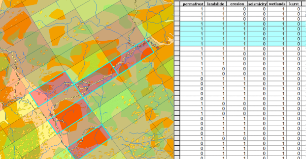
Fig. 1. Zone of increased natural and man-made danger in the Murmansk region
Based on the total cell values, a general ranked hazard map of spatially distributed risks for the territory of the Arctic zone of the Russian Federation was created. It is shown in Figure 2.
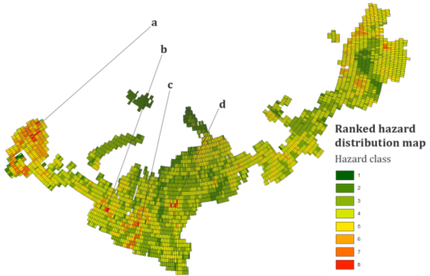
Fig. 2. General ranking map of spatially distributed risks of the Arctic zone of the Russian Federation
As a zoning result of 11 risk factors, the maximum recorded factor value in the cell is 8. This indicator corresponds to the 8th hazard class for the general ranked hazard map. Based on this indicator, 4 zones of increased danger were identified:
a) The zone of increased danger of the «Murmansk node». It consists of settlements such as Murmansk, Monchegorsk, Olenegorsk, Kirovsk and Revda. The site is characterized by a developed infrastructure — the developed infrastructure of roads and railways. The boundary of permafrost passes through this zone, there are also wetlands, landslide processes and gully erosion.
b) «Labytnangi ̶ Salekhard» zone is located in the Yamalo-Nenets Autonomous District. The risk factors here are: the presence of gas pipelines, roads and railways, wetlands, permafrost, landslide processes.
c) Zone «Noyabrsk ̶ Hanymey ̶ Gubkinsky ̶ Purpe ̶ Tarko-Sale ̶ Purovsk». In this region all man-made risk factors are present: oil pipelines, gas pipelines, highways, railways, settlements. These factors add the presence of permafrost, and severe marshiness of the territory.
d) The nodal zone of settlements belonging to the Norilsk industrial region (the city of Norilsk and Talnakh), as well as the city of Dudinka, is located in the north of the Krasnoyarsk region. Active risk factors in this area are: the presence of permafrost, landslides, wetlands, developed infrastructure (railways and roads), as well as the presence of a gas pipeline running through the territory.
The performed homogeneous zoning is considered to be a preliminary assessment of risk levels and does not intend to be an in-depth evaluation of all risk factors. Nevertheless, it provides a fairly clear picture of the spatially distributed risks causing development of hazardous situations in the Arctic zone of the Russian Federation. This assessment allows us to identify nodal zones where the study should be continued with the involvement of larger-scale cartographic material and more advanced zoning methods.
References:
- Blanutsa V. I. Integral’noe ekologicheskoe raionirovanie: kontseptsiya i metody [Integral Ecological Zoning: Concept and Methods]. Novosibirsk: Nauka Publ., 1993. 158 p.
- Primer on Natural Hazard Management in Integrated Regional Development Planning, Washington, D.C. 1991 — URL: http://www.oas.org/usde/publications/Unit/oea54e/begin.htm (accessed 01.06.19)
